What Are Lava Zones in Hawaii?
There are 9 lava zones for the five volcanoes (Kīlauea, Mauna Loa, Mauna Kea, Hualālai, and Kohala) on the Big Island. Per the US Geological Survey, USGS, “the zones, ranked from 1 through 9, represent a scale of decreasing hazard as the numbers increase, based on the probability of coverage by lava flows.
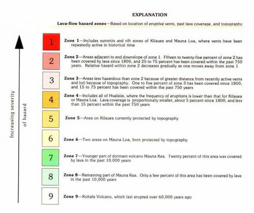
Per USGS, the hazard zones are based on the locations of probable eruption sites, past eruption sites, paths of lava flows, and the frequency of lava flow inundation of an area over the past several thousand years. The lava zone maps are intended to determine long term hazards, assuming future eruptions are similar to the past. The boundaries of these zones are gradual, and the hazard decreases as you move further from an eruptive vent.
The lava flow maps were developed for general planning purposes and designed to show the relative hazard across Hawaii Island. Therefore, the purpose is to convey volcanic hazard rather than risk. The USGS FAQ page has a great definition of hazard versus risk. As a result, buyers should do their due diligence to understand the hazards and risks when speaking with their lenders and insurance carriers about the cost impact of interest rates and policies for buying in Lava Zone 1 or 2.
In What Lava Zone Is a Property Located?
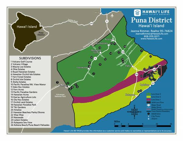
Looking at Lava Zone maps can be tricky. As stated previously, the boundaries are gradual and not a hard set line. The current lava map is also 20 years old and provides a very broad look at Hawaii Island. Typically, you would need to overlay several maps including the lava zone map to identify if a property is located in a particular lava zone.
As a Realtor, I educate Buyers on the areas and where to look based on their level of risk when purchasing. I primarily work with Buyers and Sellers in the Puna area, which is on the east side of Hawaii Island. Another factor is your home insurance in lava zones when buying a home on Big Island.
The District of Puna has 3 different lava zones and includes the towns of Kea’au, Kurtistown, Mountain View, Volcano, and Pahoa. I have created this map of the Puna District to provide clarity on the lava zone location and the neighborhoods within those zones.
Contact Me
I hope this map will be another resource to quickly identify the lava zone of the subdivision located in the Puna area. Contact me to discuss the Puna area and the advantages of buying here, and check out current listings and find out what is available.
Beth Thoma Robinson
March 30, 2020
I will have to bookmark this post! Thanks, Jeanna