Understanding Hawaii’s Lava Zones: What Homebuyers Need to Know
If you’re considering buying property on the Big Island of Hawai‘i, you’ve probably heard the term “lava zones.” Knowing what lava zones mean—and how they affect property value, insurance, and risk—is essential for any homebuyer.
What Are Lava Zones?
There are 9 lava zones for the five volcanoes (Kīlauea, Mauna Loa, Mauna Kea, Hualālai, and Kohala) on the Big Island.
Per the US Geological Survey, USGS, “the zones, ranked from 1 through 9, represent a scale of decreasing hazard as the numbers increase, based on the probability of coverage by lava flows.“
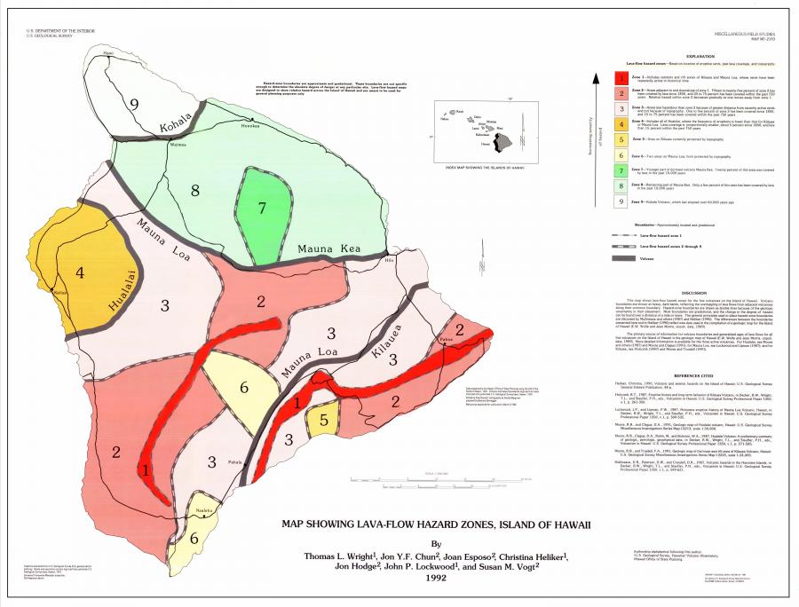
Per USGS, the hazard zones are based on the locations of probable eruption sites, past eruption sites, paths of lava flows, and the frequency of lava flow inundation of an area over the past several thousand years. The lava zone maps are intended to determine long term hazards, assuming future eruptions are similar to the past. The boundaries of these zones are gradual, and the hazard decreases as you move further from an eruptive vent.
The lava flow maps were developed for general planning purposes and designed to show the relative hazard across Hawaii Island. Therefore, the purpose is to convey volcanic hazard rather than risk. The USGS FAQ page has a great definition of hazard versus risk. As a result, buyers should do their due diligence to understand the hazards and risks when speaking with their lenders and insurance carriers about the cost impact of interest rates and policies for buying in Lava Zone 1 or 2.
What Lava Zone is a Property Located in?
Looking at Lava Zone maps can be tricky. Boundaries are gradual and not a hard set line. The current lava map is also 20 years old and provides a very broad look at Hawaii Island. Typically, you would need to overlay several maps including the lava zone map to identify if a property is located in a particular lava zone.
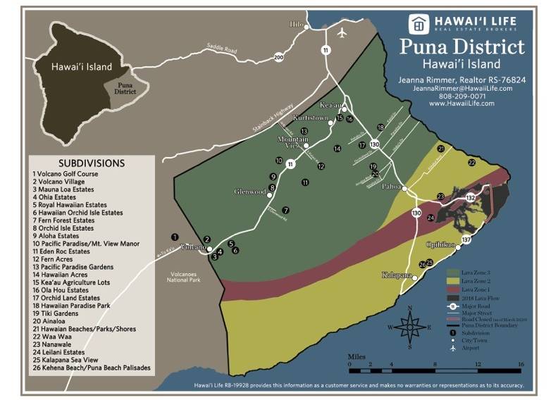
As a Hawaii Life Realtor, I educate Buyers on the areas and where to look based on their level of risk when purchasing. I primarily work with Buyers and Sellers in the Puna area, which is on the east side of Hawaii Island.
The District of Puna has 3 different lava zones and includes the towns of Kea’au, Kurtistown, Mountain View, Volcano, and Pahoa. I have created this map of the Puna District to provide clarity on the lava zone location and the neighborhoods within those zones.
Can You Get Homeowners Insurance in a Lava Zone?
Homeowners insurance is available for all lava zones on Hawaii Island, but the cost varies by the lava zone. Currently in lava zone 1 and 2, the only insurance that is available is through the state insurance fund, Hawaii Property Insurance Association (HPIA). Since this is the only provider rates are higher and the maximum amount of coverage allowed is $450,000. On average for a 1,200 sf home you can expect annual premiums to be approximately $6,000.00.
For comparison, a homeowners policy for lava zone 3 or higher is about $1,400.00 per year and you will have numerous choices for coverage. If you purchase a home in lava zone 1 or 2 and get a mortgage, the cost of insurance is a big factor in the loan qualification.
Should You Buy Property in a Lava Zone?
Some of the most beautiful and affordable properties on the Big Island are found in Lava Zones 1 and 2, especially in areas like Puna and Kea‘au. However, they come with added risk and cost considerations.
If you are considering buying in these areas make sure you lender is aware, as they will need to adjust your loan amount for the higher insurance premium. Also homeowner’s policies are not available for homes built without obtaining the proper building permits. Buyers can purchase a contents policy, similar to a renter’s policy, to mitigate loss.
Before buying, make sure to:
- Research the neighborhood’s volcanic history
- Understand what your insurance policy covers (and doesn’t)
- Set aside an emergency fund for potential mitigation or repairs
Thinking About Buying in a Lava Zone?
Contact us today to learn more about buying property in Hawaii’s lava zones and explore Big Island real estate.
Thomas Shalifoe
July 15, 2023
If the square footage is 600 would the cost be much less. Or does that matter.