Chapter 205 of the Hawaiʻi Revised Statutes requires that all land in Hawaiʻi be designated into one of four land use districts: Urban, Rural, Agricultural and Conservation. Note that the state land use district classification is not the same as Zoning, which is left to the counties — but it does limit which county zoning can be assigned. Even more confusing, sometimes a single parcel can be in two districts. Most commonly this is seen where a portion of the parcel is in Conservation (think oceanfront or forest/watershed) and the remainder in one of the other three districts.
Here is a link to an article I wrote five years ago on the topic of State Land Use Designation or County Zoning. This article expands on that post, explaining the importance of understanding the conservation districtʻs subzone classifications (again “zone” not zoning) if you happen to buy or own a property with a conservation classification.
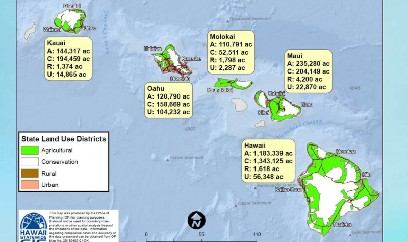
Map showing Hawaii statewide land use designations and the amount of acreage designated Agricultural, Conservation, Rural and Urban by county (each island other than Maui is a county)
What are the Conservation Subdistrict Subzones in the State of Hawaiʻi?
If you are buying (or own) a property in Agricultural, Rural, or Urban district, most likely the County Code governing zoning will tell you what you need to know regarding what you can do with the property. If you have an oceanfront property, or one that is classified as Conservation for reasons other than coastal zone management, you need to know three things instead of just two: District; Conservation Subzone; and County Zoning.
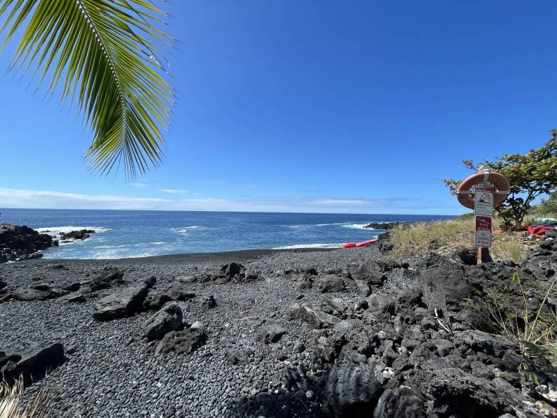
This near-oceanfront parcel turned out to be in Conservation District Limited Subzone – the owner discovered he was not able to build a home
To further manage Conservation District, five subzones were created: Protective, Limited, Resource, General and Special. The first four subzones are arranged in a hierarchy of environmental sensitivity, ranging from the most environmentally sensitive (Protective) to least sensitive (General). Logically, the Special subzone is for special properties and defines a unique land use on a specific site.
If you buy an oceanfront property in an area with other homes, most likely you will find that your conservation subzone is in the least sensitive subzones, “general” or “resource,” allowing the most lenient list of potential uses including residential. However, last month I ran across a situation in the Kona Paradise subdivision in South Kona that provides a cautionary tale.
This subdivision parcel was assigned to the limited subzone, the second most restrictive. The lot had changed hand a couple of times, and has homes already built on lots adjacent to it, so no one had checked on the subzone, simply making an assumption that a home could be built with appropriate permits. My mother always warned me that ASSUME makes…
When the newest owner hired an architect to design his residence, he learned that the lot was not buildable. The actual statutory language was confusing. If the lot had also been in a flood zone or coastal high hazard zone, a single family home would be allowed with a conservation district use permit. But because the lot did not fall in those hazard zones, which should have logically made it a lower risk, no permit could be given.
We verified this directly with the Department of Land and Natural Resources.
How Do I Find the Land Use District and Conservation Subzone for my Hawaii Property
So you have selected a beautiful piece of vacant land to purchase in Hawaiʻi and opened escrow. You now you know why it is important to verify its Hawaii State land use district, as well as looking at its County zoning, while you are in the due diligence phase .
The land use districts are administered by the State of Hawaii Land Use Commission and the Department of Land and Natural Resources (DLNR). Here is a link to the district maps by island.
Within the DLNR is an Office of Conservation and Coastal Lands with jurisdiction over conservation district and coastal zone management concerns. Here are is a link to the maps for conservation district subzones, an interactive version.
After five years of our Hawaiʻi Life Conservation and Legacy Lands practice I still am learning every day. Too often I find that listing agents and sellers are confused about (or between) zoning and state land use. Consulting a real estate attorney or land use planner would be a good move for prospective buyers of any vacant land parcel where conservation zoning applies to where you would plan to build your home.

Leave your opinion here. Please be nice. Your Email address will be kept private, this form is secure and we never spam you.